Rising Groundwater in Central London
contributed by Dr Michael Jones of Thames Water
Impact of Past Groundwater Development
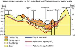
Thames Water © 2007, Schematic representation
of the bedrock geology of the London Basin
and Chalk groundwater levels
As London expanded in the 19th century, and the industrial, commercial and public demand for water increased, groundwater became increasingly important as a source of supply. In central London, underlain by the London Clay and the silts, sands and clays of the Lambeth Group, this meant drilling into the confined Thanet Sand/Chalk aquifer that initially had artesian groundwater levels (Figure 1). Progressive increases in abstraction from the confined Chalk in the late 19th century and early 20th century eventually became unsustainable, resulting in steady groundwater level decline. After WWII groundwater abstraction started to decrease, partly as a result of declining well yields and a consequential switch to river derived public supplies. Despite this, confined Chalk groundwater levels continued to fall until the mid 1960s when a dynamic equilibrium existed for several years. By this time, groundwater levels in the centre of the London Basin had fallen by about 65 m, from about 35 m below ground level (m bgl) in 1845 to almost 100 m bgl in 1967. This resulted in dewatering of the Thanet Sands as well as the Chalk (Figure 2).
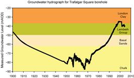
Thames Water © 2007, groundwater hydrograph
for Trafalgar Square borehole
(Chalk groundwater level)
In 1965 it is estimated that about 480 Ml/d were being abstracted from the Chalk of the London Basin. This declined steadily to about 380 Ml/d in the early 1980s, remaining relatively stable until around 1990. As abstraction from the Chalk decreased further, groundwater levels in the confined aquifer began to recover; rates of groundwater level rise reached up to 3 m per year in the centre of the Basin. In the late 1980s, the continuing groundwater level rise was recognised as a risk with potential consequences of:
- flooding of subsurface infrastructure, including deep tunnels and the basements of tall buildings; and
-
changes in geotechnical properties that could result in settlement of, for example, deeply founded structures such as tall buildings and Underground escalators.
This recognition, documented in a CIRIA report, led to action plans being developed, with London Underground, Thames Water and the Environment Agency being the key players.
The GARDIT Strategy
Although there was a clearly identifiable risk from rising groundwater levels in London, and there was much lobbying for support, there was little direct support from government to investigate and address the issue. However, in 1998 some of the stakeholders launched a 5 phase strategy that aimed to deliver an increase in actual groundwater abstraction from the confined Chalk aquifer. The aim was to deliver an increase in abstraction of 70 million litres per day (Ml/d), using this water for public and private supply, and so bring rising groundwater levels under control. This so-called GARDIT (General Aquifer Research Development and Investigation Team) Strategy was defined by Thames Water, the Environment Agency and London Underground with the support of organisations such as the Corporation of London, Envirologic, the Association of British Insurers (ABI) and BT. The 5 phases were originally defined as follows, with all except Phase 3 to be delivered by Thames Water:
- Phase 1 - Re-commissioning disused sources, 20 Ml/d
-
Phase 2 - Developing proven existing boreholes, 12 Ml/d
-
Phase 3 - Private, commercial boreholes, 20 Ml/d
-
Phase 4 - New borehole sites in central area, 15 Ml/d
-
Phase 5 - New borehole sites in outer area, 3 Ml/d
The original programme aimed to complete delivery of the full 70 Ml/d in a five year period from 1998/99 to 2003/04, with 50 Ml/d of this abstraction licensed for public water supply.
The London Basin Groundwater model was developed jointly by Thames Water and the Environment Agency to provide an over-arching decision support tool to support delivery of the GARDIT Strategy. Its aim was to improve understanding of the groundwater system and assess the benefits of the additional abstraction. Using the LBG Model to investigate the control exerted on groundwater level rise from additional abstraction, it became apparent in 2000 that 70 Ml/d was too great, and that an additional abstraction of only 50 Ml/d was more appropriate.
This revised, lower estimate of additional abstraction resulted in changes to the phasing of the GARDIT Strategy and the distribution of the new abstraction boreholes, with Phase 5 not required.
- Phase 1 - Re-commissioning disused sources, 20 Ml/d
-
Phase 2 - Developing proven existing boreholes, 21.5 Ml/d
-
Phase 3 - Private, commercial boreholes, ca. 13 Ml/d
-
Phase 4 - New borehole sites in central area, 4.2 Ml/d
The distribution of abstractions used for public supply is shown in Figure 3. Collectively, the public supply sources contributing to GARDIT in practice delivered a total of about 46 Ml/d of newly licensed abstraction which together with Phase 3 private boreholes achieved the target total of 50 Ml/d.
The GARDIT Benefit and Current Status
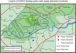
Thames Water © 2007, Location of GARDIT strategy
public water supply abstraction boreholes
From ongoing monitoring it is clear that as a result of the GARDIT strategy groundwater levels are now broadly stable in the centre of the Basin. In south west London groundwater levels are currently declining at rates of around 5 m per year in response to GARDIT abstractions and other water company abstractions to the south. Groundwater levels are still rising in north west London at rates of around 1 m per year, but here there is only low risk from these rises.
From the broad pattern of groundwater level stability and declining levels in the areas of greatest risk from high groundwater levels, it is apparent that the GARDIT Strategy has delivered and been successful in controlling the rise of Chalk groundwater levels beneath central London. As there has been a more rapid decline in groundwater levels in the central and south west London than expected, further licensing of abstractions has been restricted. The Environment Agency has, through its London Catchment Abstraction Management Strategy (CAMS), defined a policy that restricts new abstractions in central, east and south London to less than 0.5 Ml/d.
Future Resource Management
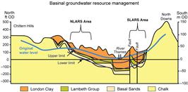
Thames Water © 2007, basinal groundwater
resources management
Through its CAMS abstraction licensing policy, the Environment Agency has established one part of the framework for the London Basin confined Chalk to become a highly managed aquifer. As there is little potential for abstraction to have an environmental impact, then providing groundwater levels can be managed to prevent impact on subsurface structures, the confined Chalk has the potential to provide a secure, sustainable source of water. Building on the principles applied in Thames Water's operational North London Artificial Recharge Scheme (NLARS)] there is potential for more widespread management of aquifer storage between upper and lower groundwater level limits (Figure 4). Using this approach, additional abstraction from the confined Chalk could be supported, with storage being replenished through artificial recharge when spare water is available. Several water companies have active programmes investigating and developing this approach.

Print this Page