SNIFFER Launch of New Hydrogeological Images on WFDVisual Website
SNIFFER (Scotland & Northern Ireland Forum for Environmental Research) is pleased to announce the addition of new groundwater images to its WFDVisual website. In October 2009, SNIFFER added a brand new suite of images for karst, floodplain, fluvial and coastal settings to WFDVisual. There are over 70 new images grouped together into storyboards to convey some commonly encountered hydrogeological scenarios. The jpeg images, which are accompanied by descriptive text, can be downloaded as a storyboard or individually.
“Being able to communicate complex hydrogeological conditions to the public has always been a challenge,” says Kirsty Irving, SNIFFER Programme Manager for Sustainable Land Use and Water Management. “But the images on this website give regulators and scientists tools that can readily be used to inform and educate both our colleagues and the public in general.”
WFDVisual has been developed by SNIFFER in partnership with the Environment Agency (England and Wales), the Geological Survey of Ireland, the Environmental Protection Agency (Republic of Ireland) and the Scottish Environment Protection Agency. The website was launched in 2007, providing specialists and non-specialists with access to thousands of images depicting different groundwater pressures within varying topographic and geological settings. The images have been developed to help communicate the complex processes underpinning the water environment and its management under the Water Framework Directive (WFD).
SNIFFER intends that the images should be used by a broad audience to help convey the importance of hydrogeological processes in managing the water environment. To that end, all images on this website are freely available to the public for non-commercial, not-for-profit use.
In contrast to the original WFDVisual images (which can be customised by the user to meet specific requirements), these new storyboard images, created by Freeman-Christie Ltd, come in pre-packaged groups to help the users explain common hydrogeological scenarios. Freeman-Christie worked with hydrological consultant Steve Fletcher, to develop initial 2D images which eventually became the final 3D visuals on the website. Through these visuals, users can quickly and easily understand the way water interacts with various elements within the British and Irish landscapes. Freeman-Christie’s director, James Freeman said “because we were involved in this project from the start we were able to work with the whole range of material available. That meant we could draw on information from diverse sources, spend time analysing it and finally developing it into teaching and learning materials”.
Each storyboard starts with an overview of the landscape; the landscape is then cut-away to help explain the hydrogeological processes. As the user moves through the images, the descriptive text helps to explain the evolving conditions.
There are seven settings for the new WFDVisual storyboards:
- Groundwater flow,
-
Floodplains,
-
Surface water & groundwater interactions,
-
Saline intrusion,
-
Groundwater pollution,
-
Karst, and
-
Monitoring.
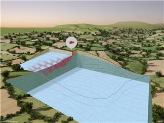
Groundwater pollution: The groundwater pollution stories display
pollution incidents in groundwater in varying strata.
Different plume diffusion means pollutants enter
the stream via different routes.
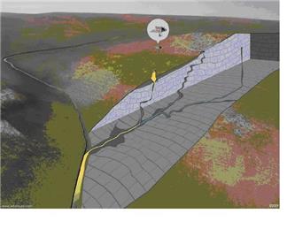
Karst: The suite of karst images show how pollutants can find
their way into river-beds via multiple routes and potentially
avoid detection.

Print this Page